From the moment explorers set foot on the ice of Antarctica in the early nineteenth century, they desired to learn what lay beneath. In The Land Beneath the Ice, David J. Drewry provides an insider’s account of the ambitious and often hazardous radar mapping expeditions that he and fellow glaciologists undertook during the height of the Cold War, when concerns about global climate change were first emerging and scientists were finally able to peer into the Antarctic ice and take its measure.
What motivated you to write this story?
DJD: For some years I had felt need to produce a coherent story about the “big science” project to map the ice thickness of Antarctica and the land that lies beneath. This is truly the last place on Earth to be surveyed. The investigations took place from the late 1960s through to the beginning of the 1980s. Recalling the size of Antarctica—twice that of Australia—it was a formidable challenge that had grown out of investigations in Cambridge, England to develop a downward looking radar capable of penetrating 5 km of ice. There followed many seasons of airborne operations in Antarctica supported by the US National Science Foundation—a continental-sized surveying endeavour. As the programme built-up there was collaboration with Danish colleagues and a steady stream of graduate students and technical staff joined the team, each one contributing ideas and expertise. So, it seemed self-evident that a book drawing these threads together should be written.
We hear a lot today about climate change and melting polar ice—did this play a part?
DJD: When we commenced our research in Antarctica ideas about global climate change were in their infancy, but quickly we saw for ourselves signs that all was not well. Over the years of our studies these signs grew stronger and other scientists began to speculate on the fate of this huge ice sheet and the important role it plays in the climate system. Our research enabled a much more precise value of how much ice is stored on the continent and its implications for sea level change. Should it all melt, which is not likely in the near future, it represents some 60 m of sea level rise! Furthermore, around the margin of the ice sheet great outlet glaciers discharge immense amounts of ice into the ocean. Their stability and response to already warming atmosphere and seas is quite critical to sea level projections. Our early surveys are providing us with some of the first reliable baselines against which to monitor such important changes.
What was it like working with the military?
DJD: We were a team of university scientists from England working for several months each year with a group of US Navy flyers operating large, ski-equipped C-130 (Hercules) aircraft in possibly the remotest and most hostile environment on Earth. Despite these “cultural” differences, as we commenced working together, each party quickly became aware of their respective professional skills. We developed the highest regard for the outstanding abilities and dedication of our USN colleagues. Without their enthusiasm we would not have achieved so much. We learnt a great deal about aircraft operations, avionics and other technical details, as well as how to fly the longest and furthest on the precious fuel load. The Navy aircrews came to share enthusiasm for our project once they came to terms with all the aerials hanging off their wings. They worked hard to squeeze as much endurance from the aircraft as possible, and their interest in the science was palpable—learning about our radar equipment and the results we were obtaining. For them this was beyond routine flying—it was airborne exploration.
What were the long flying missions like?
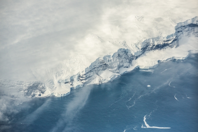
DJD: I have described a typical day of operations to give readers a feel for how our activities were planned and organised amid the continuous pressure to acquire as much data as possible. I have recounted the disruptions caused by appalling weather, aircraft problems and the circumstances we encountered while flying, such as jet-assisted take-offs, white-out landings, among other scary moments. Above all, however, we were privileged to experience the unsurpassable raw beauty of this continent, to observe what few and sometimes none had seen—great mountain chains, glaciers of immense size, the endless horizon of the ice sheet. And our radar revealed a continuous profile of an unknown continental landscape beneath the ice, hidden for millions of years. These moments were exhilarating and compensated for the noise and exhaustion during the many hours of flying.
What were some of the main discoveries you made?
DJD: Earlier seismic soundings had sketched some broad patterns, but we were commencing the new field of airborne radar sounding acquiring extraordinary quantities of quality data. On almost every flight we had fresh insights into the characteristics and behaviour of the largest ice mass in the world. A striking feature was the presence of internal reflecting horizons resulting from small dielectric contrasts—mainly produced by acids from distant volcanic activity transported by atmospheric circulation. These hundreds of layers extending almost down to the base of the ice sheet, and laterally for a thousand kilometres, were mostly time-horizons that can be correlated with the information from deep ice cores enabling much to be learned about the time-variant dynamics of the ice sheet. The large floating ice shelves and adjacent ice streams were investigated, revealing details of ice flow and processes of melting and freezing at their base, now critical for climate change studies. An extraordinary discovery was the presence of extensive bodies of water—“lakes”—lying beneath many kilometres of ice, the largest of which is almost as big as Lake Ontario. Much has been speculated about the origin, content, and the role these water bodies play and plans to sample them by drilling. Of course, we mapped the landscape beneath the ice from the network of flight lines across the continent, ultimately revealing the details of major mountain regions that had only been hinted to previously, great plains and basins as well as isolated mountain massifs—the last great undiscovered realm of our planet.
How did you present all these thousands of kilometres of sounding?
DJD: As scientists we published many of our results in learned journals, feeding our findings and ideas into the corpus of knowledge of ice sheets and global geology. We were, however, clear that we were exploring a hidden continent in unparalleled detail. This deserved presentation in an integrated manner. We conceived the idea of a folio of maps that would depict the many parameters we had deduced in detail—the surface shape of the ice sheet and its derived flowlines, the ice steams and outlet glaciers, and the ice shelves. There was an important map showing the ice thickness, and of course a map of the configuration of the land beneath the ice. Some maps were of other geophysical quantities we measured, such as the magnetic properties of the rocks below the ice. We produced a sheet on internal layering explaining its origins, characteristics and use in investigating ice sheet flow. All these maps, prepared by cartographic experts, were aesthetically pleasing and printed in colour at large scale, some at 1:6M, and collated in a large Atlas that was published by the Scott Polar Research Institute in Cambridge—the culmination of many years of work by many hands.
David J. Drewry is honorary fellow at Emmanuel College, University of Cambridge, and former director of the Scott Polar Research Institute at Cambridge and of the British Antarctic Survey. His books include Glacial Geologic Processes and Antarctica and Environmental Change. A world-renowned glaciologist, he has a mountain and a glacier named after him in Antarctica. He lives in Cottingham, England.